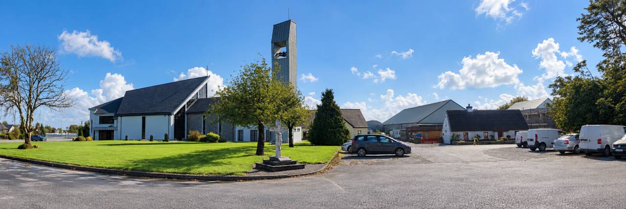
Lackagh Church and bell tower beside the green, with community buildings and the car park to the right.
Lackagh & Knockdoe

Blackthorn Solar Farm: what is proposed for our area?

Submission window closes on .

Blackthorn Solar Farm Limited has applied to build a solar farm on approximately 93 hectares in two land parcels near Lackagh and Knockdoe.

Blackthorn Solar Farm

What’s proposed?

93hectares, approximately
2land parcels

The application includes solar panels, electrical equipment, access tracks, fencing and cabling.

The 93 hectares is the overall development area, not the area covered by panels.

The wider project also includes a proposed substation beside the walking trail.

View the Council application
The place

Where is the proposal?

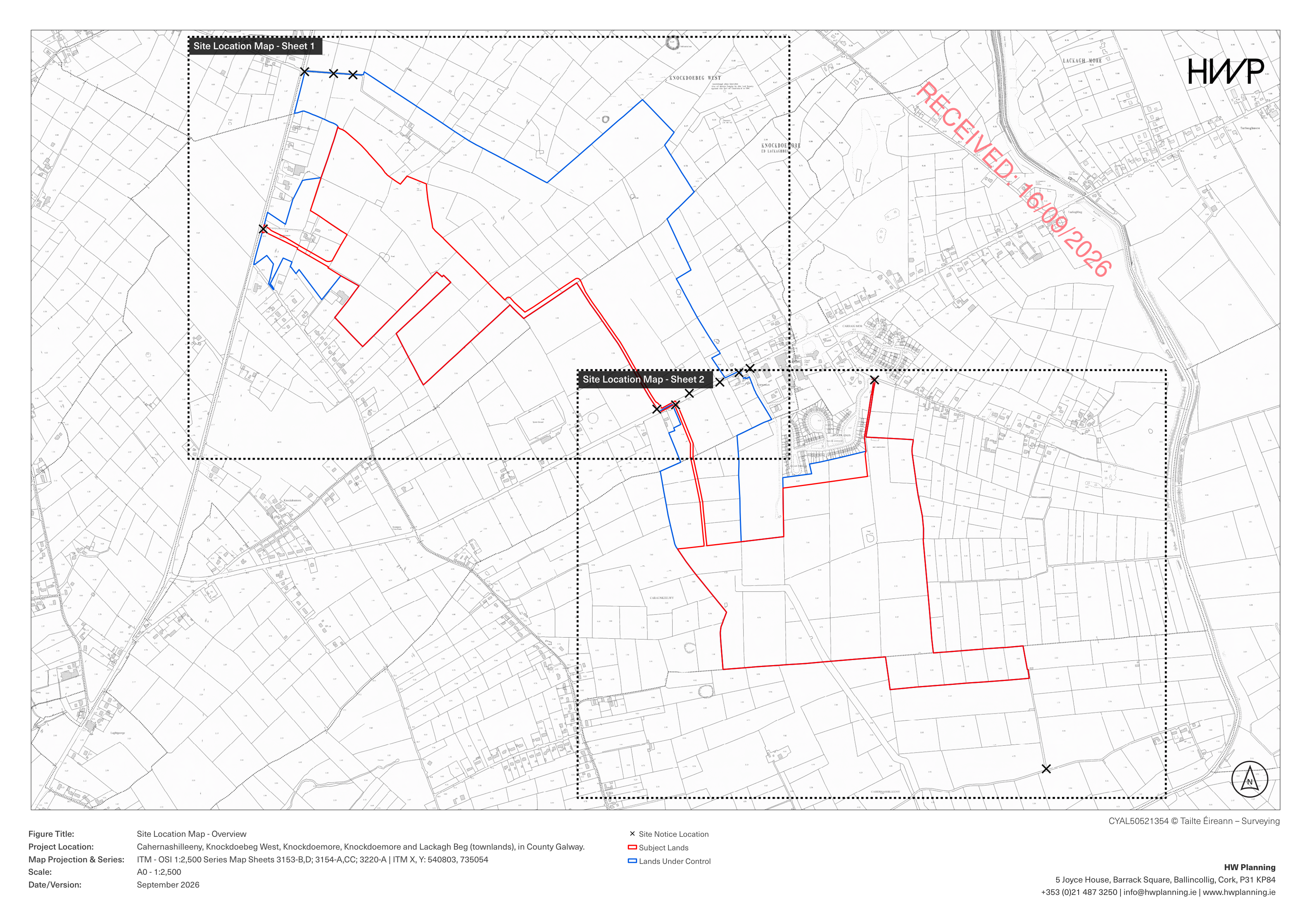
See the two proposed land parcels, covering approximately 93 hectares in total, beside local roads and amenities. Use the numbered key to find the school, church, walking trail and proposed substation, and to distinguish vehicle entrances from the underground cable corridor.

Northern parcelSouthern parcel123456C
  • 1N83 entrance
    Northern parcel
  • 2L21332 entrance
    Southern parcel
  • 3Scoil Bhríde
    Lackagh National School
  • 4Lackagh Church
    Our Lady of Knock
  • 5GAA walking trail
    Beside the northern parcel
  • 6Proposed 110 kV substation
    Separate application required
  • CUnderground cable corridor
    Between parcels, via the R354

Numbers identify locations, with short leader lines pointing to them. The dashed brown line highlights the interconnecting cable corridor; it does not show a vehicle route. The applicant also provides temporary cable-construction access drawings at the R354.

Read the access, cable and landmark sources

The application identifies the N83 and L21332 entrances for construction and operation. Delivery routes are shown in the traffic report, PDF pages 13–14. Appendix A shows the entrances and cable-construction access, PDF pages 49–52.

The electrical layout shows the cable route and proposed substation (PDF). Substation and grid-connection details in this drawing are supplied for information; they are outside the Council solar-farm application. The highlighted corridor is an orientation aid, not a survey or a drawing of every cable.

The church and school are labelled on the original Council base map. Sport Ireland’s walking-trail map shows the trail beside the northern parcel.

Red outline: subject lands. Blue outline: lands under control. Black crosses: site notice locations. Dotted rectangles: the areas covered by the two detailed sheets.

Source: the Council location drawing linked above. Checked 1 October 2026
Drawing: HW Planning. Base mapping © Tailte Éireann – Surveying, CYAL50521354.

The application at a glance

What would change locally?

The proposal would change how land near Lackagh and Knockdoe is used. Here are three parts to understand before making your views known.

Changes to the local landscape

Solar panels, fencing and electrical equipment are proposed across two land parcels. The overall development area is approximately 93 hectares.

Check the boundary and proposed planting to understand where changes could be visible from nearby homes and roads.

Construction and local roads

Building the solar farm would involve construction activity, deliveries and site access.

If you use the surrounding roads, check the proposed entrances and construction arrangements, and explain any relevant local experience in your submission.

A separate proposed substation

The applicant places a proposed 110 kV substation in the field immediately north of the Claregalway GAA walking trail at Knockdoebeg West.

It says this part of the wider project requires a separate planning application.

Source documents: Planning Statement (PDF) and Landscape and Visual Impact Assessment, page 35 (PDF).

The application explained

Frequently asked questions

How much land is shown on the map?

The applicant describes an overall development area of approximately 93 hectares across two land parcels. The red outlines show the subject lands. The 93 hectares does not mean every part would be covered by panels.

What is included besides solar panels?

The solar farm application includes associated electrical equipment, access tracks, fencing and cabling. The Planning Statement describes the proposal.

Would the solar farm operate for ten years or 40 years?

The applicant seeks a ten-year permission period to put the development in place and a separate 40-year operating life. These periods have been requested, not granted. Read the explanation and source.

Would there be a substation as well as solar panels?

The applicant proposes a 110 kV substation and grid connection as part of the wider Blackthorn project. It describes them as necessary to connect the solar farm to the national electricity network. See the Planning Statement, section 1.2.

Where would the substation be?

The applicant’s Landscape and Visual Impact Assessment places it in the field immediately north of the Claregalway GAA walking trail at Knockdoebeg West. See the submitted assessment, page 35.

Would this application approve the substation too?

No. The solar farm application is before Galway County Council. The applicant says the substation and grid connection require a separate application to An Coimisiún Pleanála.

How can I have my say on the solar farm?

The Council currently lists 20 October 2026 as the closing date for submissions on application 26/61567. A formal submission goes directly to the Council. Follow the submission guide for the times, fee and steps.

Submission deadline

Send your submission by 20 October 2026

A planning submission is your letter to the Council about the proposal. You can explain what you support, what you object to and what you want the Council to examine.

Online submissions close at 11:59 p.m. Email, post and in-person submissions must arrive by 4 p.m. All times are Ireland time.

Planning reference26/61567
Council statusNew applicationChecked 10 October 2026

Check the live Council record before sending your submission.

Check the official record
Your community

Why does it matter to you?

The proposed parcels sit near local homes and roads, and the wider project places a substation beside the Claregalway GAA walking trail.

If you live nearby, travel these roads or use the trail, your knowledge of the area can help the Council understand how the proposal relates to everyday life here.

See the proposal in detail
Three clear steps

How do you have your say?

  1. Check the plans

    See the proposed location, scale and official application documents.

    Read what’s proposed
  2. Prepare your letter

    Choose relevant topics in the builder, add your own words and save your letter.

    Build your submission
  3. Send it to the Council

    Submit the letter yourself and pay the €20 fee. The guide explains the sending options and deadlines.

    How to send your letter
From the group

Updates & meetings

All updates
Find your next step

Join the group or lend a hand

You can help neighbours find the plans, share public updates or offer time and local knowledge. Get in touch to join the group or volunteer.

Need help preparing your submission? Objection-writing workshops are being planned following the public meeting.